
On this page
Exploring the major maritime corridors that carry 90% of global trade and the strategic chokepoints that shape international commerce
Introduction: The Invisible Highways of Global Commerce
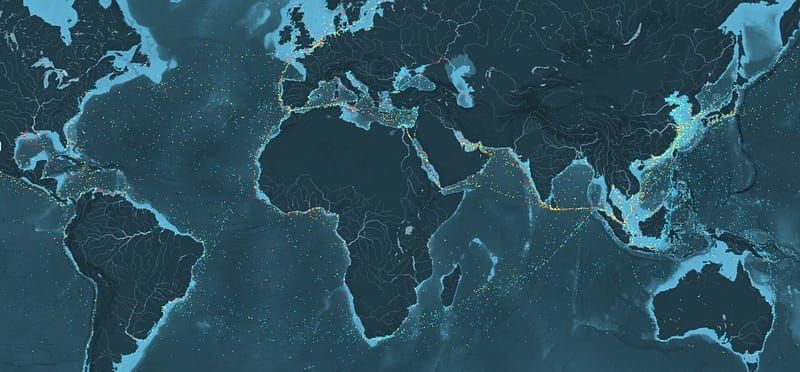
Beneath the seemingly endless expanse of our oceans lies an intricate network of shipping routes that form the circulatory system of the global economy. These maritime highways, invisible to the naked eye but crucial to modern life, carry over 11 billion tons of cargo annually — everything from the raw materials that build our cities to the finished products that fill our homes.
Understanding these shipping routes reveals the complex geography of international trade, the strategic importance of certain waterways, and how global supply chains have evolved to create our interconnected world. From the ancient Silk Road’s maritime extensions to today’s mega-container ships traversing the Pacific, shipping routes tell the story of human civilization and economic development.
1. The Architecture of Global Maritime Trade
Primary Trade Lanes: The Big Three
The world’s maritime trade is dominated by three major trade lanes that collectively handle the majority of global containerized cargo:
- Trans-Pacific Route (Asia-North America) This is the world’s busiest container shipping route, connecting the manufacturing powerhouses of East Asia with the massive consumer markets of North America.
- Trans-Atlantic Route (Europe-North America) The historic trade route that has connected the Old and New Worlds for centuries, now carrying sophisticated manufactured goods, chemicals, and high-value commodities.
- Asia-Europe Route The longest of the major trade lanes, this route connects Asian manufacturing centers with European markets via either the Suez Canal or around the Cape of Good Hope.
1.1 The Trans-Pacific: The World’s Busiest Highway
Route Characteristics and Volume
The Trans-Pacific route carries approximately 26 million TEU (Twenty-foot Equivalent Units) annually, making it the world’s largest trade lane by volume. This route typically involves journeys of 5,000 to 8,000 nautical miles, taking 12–16 days depending on the specific ports of call.
Major Port Pairs:
- Shanghai/Ningbo to Los Angeles/Long Beach
- Shenzhen to Seattle/Tacoma
- Busan to Oakland/San Francisco
- Yokohama to Vancouver
Cargo Composition and Trade Dynamics
Eastbound (Asia to North America):
- Consumer electronics and manufactured goods
- Textiles and apparel
- Automotive parts and machinery
- Furniture and home goods
Westbound (North America to Asia):
- Agricultural products (soybeans, corn, wheat)
- Raw materials and recycled materials
- Forest products and lumber
- High-tech components and aircraft parts
The eastbound trade significantly outweighs westbound cargo, creating a trade imbalance that has shaped vessel positioning and freight rates for decades.
Strategic Considerations
The Trans-Pacific route’s importance extends beyond economics into geopolitical strategy. The route passes through several strategic areas including:
- The Taiwan Strait
- The South China Sea
- The Philippine Sea
- The approaches to major Japanese ports
1.2 The Asia-Europe Route: The Longest Journey
The Suez Canal Route
The primary Asia-Europe route passes through the Suez Canal, creating a journey of approximately 11,000–13,000 nautical miles from major Asian ports to Northern European destinations. This route typically takes 20–24 days.
Key Segments:
- Asian Departure Ports: Singapore, Port Klang, Shanghai, Ningbo
- Indian Ocean Transit: Via the Strait of Malacca
- Red Sea Passage: Through the Bab el-Mandeb strait
- Suez Canal Transit: The crucial 120-mile shortcut
- Mediterranean Crossing: To European ports
- European Destinations: Rotterdam, Hamburg, Antwerp, Felixstowe
Alternative: The Cape Route
When the Suez Canal is blocked or rates are prohibitive, ships take the Cape of Good Hope route around Africa, adding approximately 3,500 nautical miles and 10–14 days to the journey.
When the Cape Route is Used:
- Suez Canal closures or delays
- Very large crude carriers (VLCCs) too big for Suez
- Economic considerations during low canal traffic periods
- Geopolitical tensions affecting Red Sea security
Cargo Characteristics
Asia to Europe:
- Consumer electronics and appliances
- Textiles and clothing
- Machinery and industrial equipment
- Automotive parts and components
Europe to Asia:
- Luxury goods and branded products
- Machinery and specialized equipment
- Chemicals and pharmaceuticals
- Automotive vehicles and parts
1.3 The Trans-Atlantic: The Historic Connection
Route Evolution and Modern Characteristics
The Trans-Atlantic route, with a history dating back centuries, remains vital for trade between Europe and the Americas. Modern container services typically cover 3,000–4,000 nautical miles in 6–8 days.
Major Trade Corridors:
- Northern Europe to US East Coast
- Mediterranean to US East/Gulf Coasts
- Europe to South America (particularly Brazil and Argentina)
- North America to West Africa
Specialized Trade Patterns
Eastbound (Americas to Europe):
- Agricultural products and food
- Raw materials and commodities
- Forest products
- Energy products (LNG, refined petroleum)
Westbound (Europe to Americas):
- Manufactured goods and machinery
- Chemicals and pharmaceuticals
- Automotive products
- Luxury and high-value goods
2. Strategic Chokepoints: The Vulnerable Arteries
The Suez Canal: Gateway Between Worlds
The Suez Canal handles approximately 10% of global trade and 30% of all container traffic. This 120-mile artificial waterway saves ships from the 6,000-mile journey around Africa.
Critical Statistics:
- Over 20,000 ships transit annually
- Handles $1 trillion in goods per year
- Can accommodate ships up to 20.1 meters draft
- Ever Given blockage in 2021 demonstrated global vulnerability
Economic Impact:
- Saves 8–10 days transit time versus Cape route
- Generates over $6 billion annually for Egypt
- Canal fees represent 2–3% of cargo value for Asia-Europe trade
The Strait of Malacca: Asia’s Vital Funnel
This narrow waterway between Malaysia and Indonesia is the shortest sea route between the Indian and Pacific Oceans, handling over 25% of global maritime trade.
Strategic Importance:
- 1.5 miles at its narrowest point
- Over 100,000 ships transit annually
- Critical for Middle East oil shipments to Asia
- Alternative routes add thousands of miles
Challenges:
- Piracy concerns (historically)
- Heavy traffic congestion
- Environmental protection needs
- Political sensitivity among littoral states
The Panama Canal: Connecting Two Oceans
The Panama Canal provides a crucial shortcut between the Atlantic and Pacific, handling approximately 6% of global trade.
Recent Developments:
- 2016 expansion allows larger “Neo-Panamax” ships
- Can now handle ships up to 14,000 TEU
- Competes with US transcontinental rail for Asia-US East Coast trade
- Water level challenges due to climate change
Other Critical Chokepoints
Strait of Hormuz:
- Controls 20% of global oil shipments
- Critical for Gulf oil exports
- Geopolitically sensitive due to Iran tensions
Turkish Straits (Bosphorus and Dardanelles):
- Only passage between Black Sea and Mediterranean
- Critical for Russian and Ukrainian grain exports
- Oil and gas pipeline alternative routes
Strait of Gibraltar:
- Gateway to Mediterranean Sea
- All Mediterranean trade must pass through
- Strategic military and commercial importance
3. Regional Shipping Networks
Intra-Asian Trade: The Growth Engine
Asia’s internal trade has become increasingly important, with routes connecting:
- China’s manufacturing centers with Southeast Asian markets
- Japan and South Korea with ASEAN countries
- India’s growing economy with East Asian partners
- Australia’s commodity exports to Asian markets
Key Characteristics:
- Shorter routes (1–7 days typically)
- Higher frequency services
- Smaller, more flexible vessel sizes
- Focus on manufactured goods and components
European Feeder Networks
Europe’s complex coastline and numerous ports require extensive feeder networks connecting:
- Major hub ports (Rotterdam, Hamburg, Antwerp) with regional ports
- Mediterranean routes serving Southern Europe and North Africa
- Baltic Sea connections to Scandinavian and Eastern European markets
- UK and Ireland connections post-Brexit
Americas Coastal Networks
North America:
- US East Coast to Gulf Coast services
- Pacific Coast connections to Alaska and Mexico
- Great Lakes shipping (seasonal)
- Canadian maritime provinces connections
South America:
- Brazil’s extensive coastal network
- Pacific Coast routes serving Chile, Peru, Ecuador
- Caribbean hub-and-spoke networks
- River systems (Amazon, Rio de la Plata)
4. Emerging Routes and Future Trends
The Arctic: The Final Frontier
Climate change is opening new possibilities in Arctic shipping:
Northern Sea Route (Russia):
- Connects Europe and Asia via Russian Arctic
- Potentially 40% shorter than Suez route
- Currently limited seasonal operation
- Russian geopolitical control considerations
Northwest Passage (Canada):
- Alternative Arctic route through Canadian waters
- Even more challenging ice conditions
- Sovereignty disputes with various nations
- Environmental protection concerns
The New Silk Road: Belt and Road Initiative
China’s Belt and Road Initiative is reshaping global shipping patterns:
- Enhanced port investments along traditional routes
- New rail connections competing with maritime transport
- Digital Silk Road incorporating maritime digitalization
- Potential new port developments and route optimizations
Technology-Driven Route Optimization
Modern shipping increasingly uses technology for route planning:
- Weather routing systems for fuel efficiency
- Real-time cargo tracking and optimization
- Artificial intelligence for predictive maintenance
- Digital twin technology for port and route planning
Environmental and Sustainability Considerations
Green Shipping Corridors
The maritime industry is developing green shipping corridors to reduce emissions:
- Hydrogen fuel corridors in Northern Europe
- Ammonia fuel trials on Pacific routes
- Biofuel initiatives on major trade lanes
- Shore power connections at major ports
Route Efficiency and Emissions
Slow Steaming:
- Reduced speeds for fuel efficiency
- Extended transit times as trade-off
- Requires more vessels for same service frequency
- Significant emission reductions achieved
Alternative Fuels:
- LNG-powered vessels on major routes
- Methanol trials on container services
- Future hydrogen and ammonia adoption
- Battery electric for short-sea shipping
Economic Impact and Trade Patterns
Freight Rate Dynamics
Shipping rates fluctuate based on:
- Supply and demand imbalances
- Fuel price variations
- Seasonal trade patterns
- Geopolitical disruptions
- Port congestion and delays
Rate Setting Mechanisms:
- Spot rates for immediate cargo
- Contract rates for regular shippers
- Fuel adjustment factors
- Peak season surcharges
Supply Chain Integration
Modern shipping routes are integrated with:
- Port-centric logistics and distribution
- Rail and truck connections for inland transport
- Warehousing and fulfillment center networks
- Digital supply chain management systems
Challenges and Vulnerabilities
Climate Change Impacts
Rising sea levels and extreme weather events affect:
- Port infrastructure and accessibility
- Route planning and seasonal variations
- Insurance costs and risk assessments
- Need for climate-resilient infrastructure
Geopolitical Risks
Political tensions can disrupt established routes:
- Trade war impacts on cargo flows
- Sanctions affecting specific routes or ports
- Military conflicts disrupting chokepoints
- Sovereignty disputes over waterways
Pandemic Lessons
COVID-19 revealed shipping route vulnerabilities:
- Port closures and reduced capacity
- Crew change difficulties
- Supply chain disruptions
- Importance of route diversification
5. The Future of Global Shipping Routes
Autonomous Shipping
The development of autonomous vessels will impact route planning:
- Optimized routes without crew fatigue considerations
- 24/7 operation capabilities
- Reduced labor costs on long routes
- Enhanced safety through technology
Digitalization and Integration
Future shipping routes will feature:
- Fully integrated digital supply chains
- Real-time cargo and vessel tracking
- Predictive analytics for route optimization
- Blockchain-based documentation systems
Sustainability Requirements
Environmental regulations will reshape routes:
- Emission control areas requiring cleaner fuels
- Carbon pricing affecting route economics
- Green port requirements influencing port selection
- Circular economy principles in route planning
Conclusion: The Arteries of Global Civilization
The world’s major shipping routes represent far more than simple transportation corridors — they are the arteries through which the lifeblood of global civilization flows. These maritime highways connect producers with consumers, raw materials with manufacturing centers, and cultures with one another across vast oceanic distances.
Understanding these routes provides insight into the complex interdependencies that define our modern world. From the busiest container ships crossing the Pacific to the strategic importance of narrow chokepoints like the Suez Canal, each element of this global network plays a crucial role in maintaining the flow of goods that sustain our interconnected economy.
As we face challenges from climate change, geopolitical tensions, and technological disruption, the evolution of these shipping routes will continue to shape global trade patterns and international relations. The ships that traverse these routes today carry not just cargo, but the building blocks of our shared future.
The next time you encounter a product from another continent, take a moment to consider the remarkable journey it took across the world’s oceans, following routes that have been refined over centuries to create the efficient, if sometimes fragile, system that connects our global community.
For more insights into maritime logistics and global trade, follow our publication and join the conversation about the future of international shipping.